
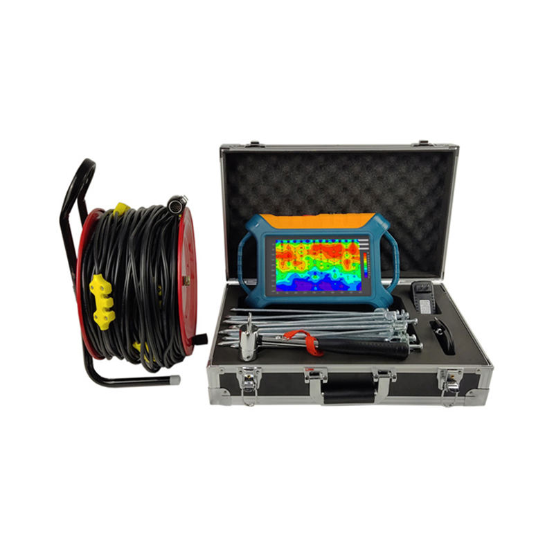


ADMT-300SX-16D Geophysical Surveying System
Introduction
The ADMT-300SX-16D Geophysical Surveying System is a high-precision underground exploration and mapping solution designed for professional geological, hydrological, mining, and energy exploration applications. Equipped with advanced transient electromagnetic technology and comprehensive 1D, 2D, and 3D data analysis software, this system delivers accurate underground detection, reliable performance, and efficient field operation for demanding surveying environments.
Specifications
| Specification | Details |
|---|---|
| Product Model | ADMT-300SX-16D |
| Product Type | Geophysical Surveying Equipment |
| Maximum Detection Depth | 300 m |
| Channel Input | 16 Channels Simultaneous Input |
| Maximum Electrode Spacing | 2.5 m |
| Channel Selection | 1–14 |
| Depth Layering | 10–80 Layers |
| Display Screen | 10.1-Inch IPS Touch Screen |
| Viewing Angle | 178° Wide Angle |
| Operating System | Android 6.0.1 |
| CPU | ARM Cortex-A7 |
| Sampling System | AD24 Bit 1Msps |
| Frequency Range | 1–8K Hz |
| Resolution | 0.01 mV ±3% |
| Sampling Time | 60–3600 Seconds |
| Warranty | 1 Year |
| Customized Support | OEM |
Key Features
- High-precision underground surveying system
- 16-channel simultaneous signal input
- Maximum detection depth of 300 meters
- Large 10.1-inch IPS touch display
- Android-based operating platform
- 1D, 2D, and 3D data analysis software
- High-resolution signal detection capability
- Durable field-ready construction
- Rechargeable power system for long operation
- OEM customization support available
Applications
- Metal mine exploration
- Coal deposit detection
- Oil and gas surveying
- Geothermal resource exploration
- Hydrological surveying
- Geological investigation projects
- Environmental and engineering surveys
Product Advantages
- High-accuracy underground detection performance
- Advanced visualization and data analysis tools
- Supports detailed geological mapping
- Reliable operation in harsh field environments
- Efficient multi-channel survey capability
Product Description
The ADMT-300SX-16D Geophysical Surveying System is engineered to provide accurate underground resource exploration and geological analysis through advanced transient electromagnetic detection technology. Featuring simultaneous 16-channel input and a maximum survey depth of 300 meters, the system delivers reliable data collection and high-resolution underground imaging.
Its integrated Android operating system and large IPS touch screen simplify field operation and data management, while advanced 1D, 2D, and 3D software tools support comprehensive survey interpretation and visualization.
System Features
- Multi-channel geophysical signal acquisition
- High-resolution underground mapping
- Real-time survey monitoring
- Advanced electromagnetic detection technology
- Wide-angle touch screen operation
Construction Features
- Rugged field-use construction
- Portable survey system design
- Durable industrial-grade components
- Stable electronic signal processing system
- Long-life rechargeable operational platform
Conclusion
The ADMT-300SX-16D Geophysical Surveying System offers a reliable, accurate, and advanced solution for underground exploration, geological surveying, mining detection, and environmental analysis applications.
Related products


Electronics & Electrical
Inflatable Foil Board Hydrofoil Surfboard Paddle E-foil Boards 5ft-8ft

